
MapInfo Pro Maintenance (12 Months)
MapInfo Pro Maintenance and Premium Services
Bring out the best in your MapInfo Pro experience.
Great ways to get the most from your GIS
You need to find new opportunities and move quickly to make your insights pay off. Maximise the value of your investment in MapInfo Pro mapping and GIS software with an annual Maintenance and Technical Support (MATS) subscription. You’ll gain peace of mind with comprehensive support services backed by an accomplished team of technical experts.
Contact US (Fast Response):
Email : cs@software-original.com
WhatsApp And Call :

0898 180 3131
MapInfo Pro Maintenance (12 Months)

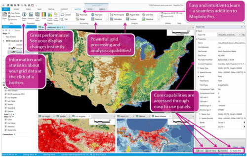
MapInfo Pro Advanced: Raster analysis, redefined.
Visualise and work with raster datasets of virtually unlimited size, without any performance penalty. With the transformative technology in MapInfo Pro Advanced, you’ll create quality visualisations and analyses in record time, while benefiting from all the capabilities of MapInfo Pro.
MapInfo Pro Advanced is our premiere 64-bit location intelligence application with a next-generation raster grid visualisation and analysis add-on. With its innovative, patented multi-resolution master (MRR) data format, it can handle datasets at terabyte scale.
Powerful and Flexible
The MRR format gives you the ability to gather and work with data at different resolutions and still generate meaningful analyses. Plus, it's supported in the Standard MapInfo Pro and throughout the Pitney Bowes Location Intelligence suite.
Plus These Outstanding Benefits
- Comprehensive visualisation options (e.g. analytical hill shading)
- Powerful grid analysis (e.g. slope calculation, line-of-sight analysis)
- Advanced grid analysis using an easy-to-use Grid Calculator
- Broad coverage: High quality maps for large parts of the world
- Up-to-date reference maps: The background data is constantly being updated
- Flexible map displays
- Instant customisation
- Robust background maps
- Smarter calculations
This single-seat desktop term license will activate the software for the purchased term. When the term expires, you must purchase a new term license to re-activate. Initial purchase includes a one year Subscription and Services package, which provides you with access to any maintenance and upgrade releases, knowledge-base articles, access to the Knowledge Community web to share ideas and best practices and access to a world-class technical support team. Support packages can be renewed annually as desired.
Overview
Update your capabilities with our new, powerful tools.
Find, segment and update your data faster and easier with the new SQL Window:
Users can build and save SQL statements and MapBasic scripts. This helps to increase productivity by building, running and reusing scripts.
Enhance your location analytics with customised apps in the Marketplace:
Customised apps are released and updated continuously to help you solve your specific business needs. Need imagery of a specific area? MapInfo Pro Drone is available. Looking for additional special purpose tools? We have an app for that, too.
Make beautiful maps with map layout improvements
Experience crisp new line and fill styles, vectorised legends, faster redraws, snapping and alignment, templates, multipage layouts.
Turn your data into insights using the new heat mapping available within MapInfo Pro:
Start with any file of people, places, or things and visualise the density of the locations as “hot spots” that help you make better decisions. For more power, upgrade to MapInfo Pro Advanced and work with all kinds of raster data using the fast, highly compressed MRR format.
MapInfo Pro Maintenance and Premium Services
Bring out the best in your MapInfo Pro experience.
Great ways to get the most from your GIS
You need to find new opportunities and move quickly to make your insights pay off. Maximise the value of your investment in MapInfo Pro mapping and GIS software with an annual Maintenance and Technical Support (MATS) subscription. You’ll gain peace of mind with comprehensive support services backed by an accomplished team of technical experts.
You’ll also get more ways to visualise your data. Your MATS subscription includes unlimited access to Bing Maps Aerial and Hybrid imagery. You can geocode addresses instantly using free credits you receive with your subscription. Add MapInfo Pro Premium Services to MATS, and you’ll have access to the most up-to-date Microsoft Bing® Road maps as well.
Perform robust location-based analysis.
Maximise performance.
Your MATS subscription provides technical resources for achieving top performance. Application updates give you maximum functionality. With MATS, you’ll automatically benefit from the newest features and enhancements as we continuously improve your MapInfo Pro experience.
Enrich visualisation and context.
Bing Maps Aerial and Hybrid imagery are included with your MATS subscription. Add MapInfo® Premium Services, and you’ll gain global access to the Bing Road map too.
Benefit from comprehensive map coverage without the cost of storing and managing the map and imagery on your systems.
Premium Services also adds a “Move Map To” feature that allows you to find any location worldwide and instantly zoom your map to it.
Add on-demand geocoding at no added cost.
MATS and Premium Services come with a select number of per-user geocoding credits.
Apply these to get on-demand access to the Pitney Bowes global geocoder. This service provides street-level coverage across more than 140 countries.
Put our technical support experts on call.
Your Maintenance and Technical Support (MATS) subscription provides access to technical support staff during business hours. You’ll benefit from:
• Advice on implementation, optimisation and troubleshooting
• Online Case Management System (OCMS) for logging and tracking support issues
• Rapid issue resolution by professionals highly experienced in the use and operation of Pitney Bowes software applications
• Online access to the Pitney Bowes knowledgebase, product documentation and other resources
Plot precise locations instantly with geocoding credits.
Your MATS subscription gives you 1,000 geocoding credits per MapInfo ProTM software user each month. When you add Premium Services to your MATS subscription, your per-user monthly credits double to 2,000.
Use these to access global geocoding right from your MapInfo Pro software via the Pitney Bowes Commerce Cloud.
Geocode a table of addresses or places across more than 140 countries, and display on your maps.
MATS subscribers get free unlimited access to worldwide Bing maps and imagery.
Identify relationships, patterns and trends faster using Bing maps as contextual background for your own business layers. Your MATS subscription comes with unlimited access to:
• Bing Aerial maps: Overlay satellite imagery onto your maps and highlight roads and major landmarks for easy identification amongst the satellite images.
• Bing Hybrid maps: Add worldwide orthographic aerial and satellite imagery with roads and labels overlaid.
Get global street details with Premium Services.
Gain faster contextual insight by overlaying worldwide street tile data onto your own data output.
Your MapInfo Pro™ Premium Services subscription gives you access to the latest Bing road maps.
• Broad worldwide coverage
• Background data that is constantly updated for accuracy
• Quick, cost-effective alternative to purchasing data for download or installation
Easy-to-use “Move Map To” feature helps you find points of interest.
If you have an address or place name, you can use the “Move Map To” capability that comes with your MapInfo Pro Premium Services subscription to centre your map view on the new location.
Experience the full value of Location Intelligence.
Perform rapid analysis and uncover opportunities when you give greater context to your data. MapInfo Pro™ subscription services support faster, better decision-making, whether you are calculating risk, locating a new site or planning where to put public services.
Specifications
OPERATING SYSTEMS – DESKTOP
– Windows 7 (64-bit SP1)
– Windows 8.1 (64-bit)
– Windows 10 (64-bit)
– Windows 2012 Server R2 (64-bit only)
– Windows 2012 Server R2 (64-bit with XenApp 7.5)
– Windows 2019 Server R2 (64-bit)
– Windows 2019 Server R2 (64-bit with XenApp)
DATA COMPATIBILITY
– Common PC files
– Microsoft® Excel
– Access
– DBF
– CSV and delimited ASCII text files
RELATIONAL AND SPATIAL DATABASES
– Oracle®
– Microsoft® SQL Server
– PostGIS
– SQLite
– ODBC compliant databases
– OGC GeoPackage (new in 16.0)
SPATIAL DATA
– AutoCAD® DXF/DWG
– SHP
– DGN
– GML
– KML
AND MORE
– Maps and imagery
– WMTS (new in 16.0)
– WMS
– WFS (version 2.0 support added)
– CSW
– Aerial images
– Satellite images
– Scanned paper mapes
– Microsoft® Bing maps


Reviews
There are no reviews yet.